The National Parks of Great Britan
Myths and literature
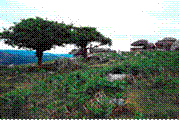
Dartmoor abounds with myths and legends. It is reputedly the haunt of pixies, a headless horseman, a mysterious pack of ‘spectral hounds’, and a large black dog. During the Great Thunderstorm of 1638, Dartmoor was even said to have been visited by the Devil.
Many landmarks have an
cient legends and ghost stories associated with them, such as Jay’s Grave, the ancient burial site at Childe’s Tomb, the rock pile called Bowerman’s Nose, and the stone crosses that mark mediaeval routes across the moor.
A few stories have emerged in recent decades, such as the ‘hairy hands’, that are said to attack travellers on the B3212 near Two Bridges.
Dartmoor has inspired a number of artists and writers, such as Sir Arthur Conan Doyle in The Hound of the Baskervilles and The Adventure of Silver Blaze, Eden Phillpotts, Beatrice Chase, Agatha Christie and the Reverend Sabine Baring-Gould.
Towns
and villages
Dartmoor has a resident population of about 33,400, which swells considerably during holiday periods with incoming tourists. For a list, expand the Settlements of Dartmoor navigational box at the bottom of this page.
Physical geography
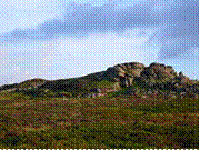
Tors.
Dartmoor is known for its tors - large hills, topped with outcrops of bedrock, which in granite country such as this are usually rounded boulder-like formations. There are over 160 tors on Dartmoor. They are the focus of an annual event known as the Ten Tors Challenge, when over a thousand people, aged between 14 and 21, walk for distances of 35, 45 or 55 miles (56, 72 or 89 km) over ten tors on many differing routes. While many of the hills of Dartmoor have the word “Tor” in them quite a number do not, however this does not appear to relate to whether there is an outcrop of rock on their summit.
The highest points on Dartmoor are High Willhays (grid reference SX580895) at 621 m (2,040 ft) and Yes Tor (grid reference SX581901) 619 m (2,030 ft) on the northern moor. Ryder’s Hill (grid reference SX690660), 515 m (1,690 ft), Snowdon 495 m (1,620 ft), and an unnamed point at (grid reference SX603645),493 m (1,620 ft) are the highest points on the southern moor. Probably the best known tor on Dartmoor is Haytor (also spelt Hey Tor) (grid reference SX757771), 457 m (1,500 ft). For a more complete list see List of Dartmoor tors and hills.
Rivers
The levels of rainfall on Dartmoor are considerably higher than in the surrounding lowlands. With much of the national park covered in thick layers of peat, the rain is usually absorbed quickly and distributed slowly, so that the moor is rarely dry.
In areas where water accumulates, dangerous bogs or mires can result. Some of these, up to 12 feet (3.7 m) across and topped with bright green moss, are known to locals as “feather beds” or “quakers", because they shift (or ‘quake’) beneath your feet. This is the result of accumulations of sphagnum moss growing over a hollow in the granite filled with water.
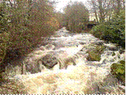
Another consequence of the high rainfall is that there are numerous rivers and streams on Dartmoor. As well as shaping the landscape, these have traditionally provided a source of power for moor industries such as tin mining and quarrying.
The Moor takes its name from the River Dart, which starts as the East Dart and West Dart and then becomes a single river at Dartmeet.
For a full list, expand the Rivers of Dartmoor navigational box at the bottom of this page.
Angling.
Angling is a popular pastime on the moor, especially for migratory fish such as salmon.
Kayaking and canoeing.
Dartmoor is a focal point for whitewater kayaking and canoeing, due to the previously mentioned high rainfall and high quality of rivers. The River Dart is the most prominent meeting place, the section known as the Loop being particularly popular, but the Erme, Plym, Tavy and Teign are also frequently paddled. There are other rivers on the moor which can be paddled, including the Walkham and Bovey. The access situation is variable on Dartmoor, some paddlers have experienced difficulties with landowners, while others have had a friendly reception.
3. Peak district national park
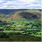
The Peak District is an upland area in central and northern England, lying mainly in northern Derbyshire, but also covering parts of Cheshire, Greater Manchester, Staffordshire, and South and West Yorkshire.
Most of the area falls within the Peak District National Park, whose designation in 1951 made it the earliest national park in the British Isles. An area of great diversity, it is conventionally split into the northern Dark Peak, where most of the moorland is found and whose geology is gritstone, and the southern White Peak, where most of the population lives and where the geology is mainly limestone-based. Proximity to the major cities of Manchester and Sheffield and the counties of Yorkshire, Lancashire, Greater Manchester, Cheshire and Staffordshire coupled with easy access by road and rail, have all contributed to its popularity. With an estimated 22 million visitors per year, the Peak District is thought to be the second most-visited national park in the world (after the Mount Fuji National Park in Japan).
History
Early history
The Peak District has been settled from the earliest periods of human activity, as is evidenced by occasional finds of Mesolithic flint artefacts and by palaeoenvironmental evidence from caves in Dovedale and elsewhere. There is also evidence of Neolithic activity, including some monumental earthworks or barrows (burial mounds) such as that at Margery Hill. [12] In the Bronze Age the area was well populated and farmed, and evidence of these people survives in henges such as Arbor Low near Youlgreave or the Nine Ladies Stone Circle at Stanton Moor. In the same period, and on into the Iron Age, a number of significant hillforts such as that at Mam Tor were created. Roman occupation was sparse but the Romans certainly exploited the rich mineral veins of the area, exporting lead from the Buxton area along well-used routes. There were Roman settlements, including one at Buxton which was known to them as “Aquae Arnemetiae” in recognition of its spring, dedicated to the local goddess.
Theories as to the derivation of the Peak District name include the idea that it came from the Pecsaetan or peaklanders, an Anglo-Saxon tribe who inhabited the central and northern parts of the area from the 6th century AD when it fell within the large Anglian kingdom of Mercia.
Medieval to modern history
In medieval and early modern times the land was mainly agricultural, as it still is today, with sheep farming, rather than arable, the main activity in these upland holdings. However, from the 16th century onwards the mineral and geological wealth of the Peak became increasingly significant. Not only lead, but also coal, copper (at Ecton), zinc, iron, manganese and silver have all been mined here. Celia Fiennes, describing her journey through the Peak in 1697, wrote of ‘those craggy hills whose bowells are full of mines of all kinds off black and white and veined marbles, and some have mines of copper, others tinn and leaden mines, in w [hi] ch is a great deale of silver. ’ Lead mining peaked in the 17th and 18th centuries and began to decline from the mid-19th century, with the last major mine closing in 1939, though lead remains a by-product of fluorspar, baryte and calcite mining (see Derbyshire lead mining history for details). Limestone and gritstone quarries flourished as lead mining declined, and remain an important industry in the Peak.
Другие рефераты на тему «Иностранные языки и языкознание»:
Поиск рефератов
Последние рефераты раздела
- Важнейшие требования к композиции документа
- Гармония речи и основные законы современной риторики
- Выразительность речи и ее условия
- Времена группы Simple
- Версия унификации и усовершенствования азерлийских национальных фамилий в Азербайджане
- Грамматика английского языка в примерах и упражнениях
- Грамматические правила русского языка