The National Parks of Great Britan
Large reservoirs such as Woodhead and Howden were built from the late 19th century onward to supply the growing urban areas surrounding the Peak District, often flooding large areas of farmland and depopulating the surrounding land in an attempt to improve the water purity.
The northern moors of Saddleworth and Wessenden gained notoriety in the 1960s as the burial site of several children m
urdered by the so-called Moors Murderers, Ian Brady and Myra Hindley.
Transport
History
The first roads in the Peak were constructed by the Romans, although they may have followed existing tracks. The Roman network is thought to have linked the settlements and forts of Aquae Arnemetiae (Buxton), Chesterfield, Ardotalia (Glossop) and Navio (Brough-on-Noe), and extended outwards to Danum (Doncaster), Manucium (Manchester) and Derventio (Little Chester, near Derby). Parts of the modern A515 and A53 roads south of Buxton are believed to run along Roman roads.
Packhorse routes criss-crossed the Peak in the Medieval era, and some paved causeways are believed to date from this period, such as the Long Causeway along Stanage. However, no highways were marked on Saxton’s map of Derbyshire, published in 1579. Bridge-building improved the transport network; a surviving early example is the three-arched gritstone bridge over the River Derwent at Baslow, which dates from 1608 and has an adjacent toll-shelter. [18] Although the introduction of turnpike roads (toll roads) from 1731 reduced journey times, the journey from Sheffield to Manchester in 1800 still took 16 hours, prompting Samuel Taylor Coleridge to remark that ‘a tortoise could outgallop us! ’From around 1815 onwards, turnpike roads both increased in length and improved in quality. An example is the Snake Road, built under the direction of Thomas Telford in 1819-21 (now the A57); the name refers to the crest of the Dukes of Devonshire. The Cromford Canal opened in 1794, carrying coal, lead and iron ore to the Erewash Canal.
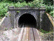
Totley Tunnel on the Manchester to Sheffield line
The improved roads and the Cromford Canal both shortly came under competition from new railways, with work on the first railway in the Peak commencing in 1825. Although the Cromford and High Peak Railway (from Cromford Canal to Whaley Bridge) was an industrial railway, passenger services soon followed, including the Woodhead Line (Sheffield to Manchester via Longdendale) and the Manchester, Buxton, Matlock and Midlands Junction Railway. Not everyone regarded the railways as an improvement. John Ruskin wrote of the Monsal Dale line: ‘You enterprised a railroad through the valley, you blasted its rocks away, heaped thousands of tons of shale into its lovely stream. The valley is gone, and the gods with it; and now, every fool in Buxton can be at Bakewell in half-an-hour, and every fool in Bakewell at Buxton.
By the second half of the 20th century, the pendulum had swung back towards road transport. The Cromford Canal was largely abandoned in 1944, and several of the rail lines passing through the Peak were closed as uneconomic in the 1960s as part of the Beeching Axe. The Woodhead Line was closed between Hadfield and Penistone; parts of the trackbed are now used for the Trans-Pennine Trail, the stretch between Hadfield and Woodhead being known specifically as the Longdendale Trail. The Manchester, Buxton, Matlock and Midlands Junction Railway is now closed between Rowsley and Buxton where the trackbed forms part of the Monsal Trail. The Cromford and High Peak Railway is now completely shut, with part of the trackbed open to the public as the High Peak Trail. Another disused rail line between Buxton and Ashbourne now forms the Tissington Trail.
Road network
The main roads through the Peak District are the A57 (Snake Pass) between Sheffield and Manchester, the A628 (Woodhead Pass) between Barnsley and Manchester via Longdendale, the A6 from Derby to Manchester via Buxton, and the Cat and Fiddle road from Macclesfield to Buxton. These roads, and the pretty minor roads and lanes, are attractive to drivers, but the Peak’s popularity makes road congestion a significant problem especially during summer.
Public transport
The Peak District is readily accessible by public transport, which reaches even central areas. Train services into the area are the Hope Valley Line from Sheffield and Manchester; the Derwent Valley Line from Derby to Matlock; and the Buxton Line and the Glossop Line linking those towns to Manchester. Coach (long-distance bus) services provide access to Matlock, Bakewell and Buxton from Derby, Nottingham and Manchester, and there are regular buses from the nearest towns such as Sheffield, Glossop, Stoke, Leek and Chesterfield. The nearest airports are Manchester, East Midlands and Doncaster-Sheffield.
For such a rural area, the smaller villages of the Peak are relatively well served by internal transport links. There are many minibuses operating from the main towns (Bakewell, Matlock, Hathersage, Castleton, Tideswell and Ashbourne) out to the small villages. The Hope Valley and Buxton Line trains also serves many local stations (including Hathersage, Hope and Edale).
Geography
The Peak District forms the southern end of the Pennines and much of the area is uplands above 1,000 feet (300 m), with a high point on Kinder Scout of 2,087 feet (636 m). Despite its name, the landscape lacks sharp peaks, being characterised by rounded hills and gritstone escarpments (the “edges”). The area is surrounded by major conurbations, including Huddersfield, Manchester, Sheffield, Derby and Stoke-on-Trent.
The National Park covers 555 square miles (1,440 km2) of Derbyshire, Staffordshire, Cheshire, Greater Manchester and South and West Yorkshire, including the majority of the area commonly referred to as the Peak. The Park boundaries were drawn to exclude large built-up areas and industrial sites from the park; in particular, the town of Buxton and the adjacent quarries are located at the end of the Peak Dale corridor, surrounded on three sides by the Park. The town of Bakewell and numerous villages are, however, included within the boundaries, as is much of the (non-industrial) west of Sheffield. As of 2006, it is the fourth largest National Park in England and Wales. As always in Britain, the designation “National Park” means that there are planning restrictions to protect the area from inappropriate development, and a Park Authority to look after it-but does not imply that the land is owned by the government, or is uninhabited.
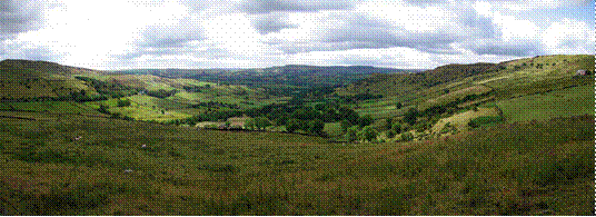
High Peak panorama between Hayfield and Chinley
12% of the Peak District National Park is owned by the National Trust, a charity which aims to conserve historic and natural landscapes. It does not receive government funding. The three Trust estates (High Peak, South Peak and Longshaw) include the ecologically or geologically significant areas of Bleaklow, Derwent Edge, Hope Woodlands, Kinder Scout, Leek and Manifold, Mam Tor, Dovedale, Milldale and Winnats Pass. The Peak District National Park Authority directly owns around 5%, and other major landowners include several water companies.
Другие рефераты на тему «Иностранные языки и языкознание»:
Поиск рефератов
Последние рефераты раздела
- Важнейшие требования к композиции документа
- Гармония речи и основные законы современной риторики
- Выразительность речи и ее условия
- Времена группы Simple
- Версия унификации и усовершенствования азерлийских национальных фамилий в Азербайджане
- Грамматика английского языка в примерах и упражнениях
- Грамматические правила русского языка