The National Parks of Great Britan
In Neolithic times, the Lake District was a major source of stone axes, examples of which have been found all over Britain. The primary site, on the slopes of the Langdale Pikes, is sometimes described as a "stone axe factory" of the Langdale axe industry. Some of the earliest stone circles in Britain are
connected with this industry.
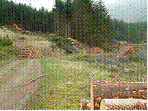
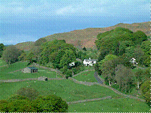
Since Roman times, farming, in particular of sheep, was the major industry in the region. The breed most closely associated with the area is the tough Herdwick, with Rough Fell and Swaledale sheep also common. Sheep farming remains important both for the economy of the region and for preserving the landscape which visitors want to see. Features such as dry stone walls, for example, are there as a result of sheep farming. Some land is also used for silage and dairy farming. There are extensive plantations of non-native pine trees.
The area was badly affected by the foot-and-mouth outbreak across the United Kingdom in 2001. Thousands of sheep, grazing on the fellsides across the District, were destroyed. In replacing the sheep, one problem to overcome was that many of the lost sheep were heafed, that is, they knew their part of the unfenced fell and did not stray, with this knowledge being passed between generations. With all the sheep lost at once, this knowledge has to be re-learnt and some of the fells have had discreet electric fences strung across them for a period of five years, to allow the sheep to "re-heaf".
Mining, particularly of copper, lead (often associated with quantities of silver), baryte, graphite and slate, was historically a major Lakeland industry, mainly from the 16th century to the 19th century. Coppiced woodland was used extensively to provide charcoal for smelting. Some mining still takes place today-for example slate mining continues at the Honister Mines, at the top of Honister Pass. Abandoned mine-workings can be found on fell-sides throughout the district. The locally-mined graphite led to the development of the pencil industry, especially around Keswick.
In the middle of the 19th century, half the world textile industry's bobbin supply came from the Lake District area. Over the past century, however, tourism has grown rapidly to become the area's primary source of income.
Development of tourism
Early visitors to the Lake District, who travelled for the education and pleasure of the journey, include Celia Fiennes who in 1698 undertook a journey the length of England, including riding through Kendal and over Kirkstone Pass into Patterdale. Her experiences and impressions were published in her book Great Journey to Newcastle and Cornwall:
As I walked down at this place I was walled on both sides by those inaccessible high rocky barren hills which hang over one’s head in some places and appear very terrible; and from them springs many little currents of water from the sides and clefts which trickle down to some lower part where it runs swiftly over the stones and shelves in the way, which makes a pleasant rush and murmuring noise and like a snowball is increased by each spring trickling down on either side of those hills, and so descends into the bottoms which are a Moorish ground in which in many places the waters stand, and so form some of those Lakes as it did here.
In 1724, Daniel Defoe published the first volume of A Tour Thro' the Whole Island of Great Britain. He commented on Westmorland that it was:
the wildest, most barren and frightful of any that I have passed over in England, or even Wales itself; the west side, which borders on Cumberland, is indeed bounded by a chain of almost unpassable mountains which, in the language of the country, are called fells.
Towards the end of the 18th century, the area was becoming more popular with travellers. This was partly a result of wars in Continental Europe, restricting the possibility of travel there. In 1778 Father Thomas West produced A Guide to the Lakes, which began the era of modern tourism.
West listed "stations"-viewpoints where tourists could enjoy the best views of the landscape, being encouraged to appreciated the formal qualities of the landscape and to apply aesthetic values. At some of these stations, buildings were erected to help this process. The remains of Claife Station (on the western shore of Windermere below Claife Heights) can be visited today.
William Wordsworth published his Guide to the Lakes in 1810, and by 1835 it had reached its fifth edition, now called A Guide through the District of the Lakes in the North of England. This book was particularly influential in popularising the region. Wordsworth's favourite valley was Dunnerdale or the Duddon Valley nestling in the south-west of the Lake District.
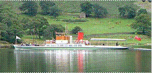
The railways led to another expansion in tourism. The Kendal and Windermere Railway was the first to penetrate the Lake District, reaching Kendal in 1846 and Windermere in 1847. The line to Coniston opened in 1848 (although until 1857 this was only linked to the national network with ferries between Fleetwood and Barrow-in-Furness); the line from Penrith through Keswick to Cockermouth in 1865; and the line to Lakeside at the foot of Windermere in 1869. The railways, built with traditional industry in mind, brought with them a huge increase in the number of visitors, thus contributing to the growth of the tourism industry. Railway services were supplemented by steamer boats on the major lakes of Ullswater, Windermere, Coniston Water, and Derwent Water.
The growth in tourist numbers continued into the age of the motor car, when railways began to be closed or run down. The formation of the Lake District National Park in 1951 recognised the need to protect the Lake District environment from excessive commercial or industrial exploitation, preserving that which visitors come to see, without (so far) any restriction on the movement of people into and around the district. The M6 Motorway helped bring traffic to the Lakes, passing up its eastern flank. The narrow roads present a challenge for traffic flow and, from the 1960s, certain areas have been very congested.
Whilst the roads and railways provided easier access to the area, many people were drawn to the Lakes by the publication of the Pictorial Guide to the Lakeland Fells by Alfred Wainwright. First published between 1952 and 1965, these books provided detailed information on 214 peaks across the region, with carefully hand-drawn maps and panoramas, and also stories and asides which add to the colour of the area. They are still used by many visitors to the area as guides for walking excursions, with the ultimate goal of bagging the complete list of Wainwrights. The famous guides are being revised by Chris Jesty to reflect changes, mainly in valley access and paths.
Другие рефераты на тему «Иностранные языки и языкознание»:
Поиск рефератов
Последние рефераты раздела
- Важнейшие требования к композиции документа
- Гармония речи и основные законы современной риторики
- Выразительность речи и ее условия
- Времена группы Simple
- Версия унификации и усовершенствования азерлийских национальных фамилий в Азербайджане
- Грамматика английского языка в примерах и упражнениях
- Грамматические правила русского языка