The National Parks of Great Britan
Exmoor has been the setting for several novels including the 19th-century Lorna Doone: A Romance of Exmoor by Richard Doddridge Blackmore, and Margaret Drabble’s 1998 novel The Witch of Exmoor. The park was featured on the television programme Seven Natural Wonders twice, as one of the wonders of the West Country.
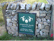
8. Yorkshire Dales
The Yorkshire Dales (also known as T
he Dales) is the name given to an upland area, in Northern England.
The area lies within the historic county boundaries of Yorkshire, though it spans the ceremonial counties of North Yorkshire, West Yorkshire, and Cumbria. Most of the area falls within the Yorkshire Dales District National Park, created in 1954, and now one of the twelve National parks of England and Wales (not including the South Downs which is due to become one).
The Dales is a collection of river valleys and the hills in between them, rising from the Vale of York westwards to the hilltops of the main Pennine watershed (the British English meaning). In some places the area even extends westwards across the watershed, but most of the valleys drain eastwards to the Vale of York-into the Ouse and then the Humber.
The word dale comes from a Nordic/Germanic word for valley, and occurs in valley names across Yorkshire (and northern England generally) but since the creation of the Yorkshire Dales National park, the name Yorkshire Dales has come to refer specifically to these western dales and the area of dales and hills east of the Vale of York is now called the North York Moors after the National Park created there
Yorkshire Dales National Park
In 1954 an area of 1,770 square kilometres (680 sq mi) was designated the Yorkshire Dales National Park. Most of the National Park is in North Yorkshire, though part lies within Cumbria. However, the whole park lies within the traditional boundaries of Yorkshire, divided between the North Riding and the West Riding. The park is 50 miles (80 km) north east of Manchester; Leeds and Bradford lie to the south, while Kendal is to the west and Darlington to the east.
Over 20,000 residents live and work in the park, which attracts over eight million visitors every year. The area has a large collection of activities for visitors. For example, many people come to the “Dales” for walking or exercise. The National Park is crossed by several long-distance routes including the Pennine Way, the Dales Way, the Coast to Coast Path and the latest national trail - the Pennine Bridleway. Cycling is also popular and there are several cycleways.
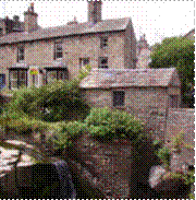
The Park has its own museum, the Dales Countryside Museum, housed in a conversion of the Hawes railway station in Wensleydale in the north of the Park. The park has 5 visitor centres located in major destinations in the park. These are at:
Geography
Most of the dales in the Yorkshire Dales are named after their river or stream (eg Arkengarthdale, formed by Arkle Beck). The best-known exception to this rule is Wensleydale, which is named after the town of Wensley rather than the River Ure, although an older name for the dale is Yoredale. In fact, valleys all over Yorkshire are called “ (name of river) +dale”-but only the more northern Yorkshire valleys (and only the upper, rural, reaches) are included in the term “The Dales". For example, the southern boundary area lies in Wharfedale and Airedale. The lower reaches of these valleys are not usually included in the area, and Calderdale much further south, would never normally be referred to as part of “The Dales" even though it is a dale, is in Yorkshire, and the upper reaches are as scenic and rural as many valleys further north.
Geographically, the classical Yorkshire Dales spread to the north from the market and spa towns of Settle, Deepdale near Dent, Skipton, Ilkley and Harrogate in North Yorkshire, with most of the larger southern dales (e. g. Ribblesdale, Malhamdale and Airedale, Wharfedale and Nidderdale) running roughly parallel from north to south. The more northerly dales (e. g. Wensleydale, Swaledale and Teesdale) running generally from west to east. There are also many other smaller or lesser known dales (e. g. Arkengarthdale, Barbondale, Bishopdale, Clapdale, Coverdale, Dentdale and Deepdale, Garsdale, Kingsdale, Littondale, Langstrothdale, Raydale, Waldendale and the Washburn Valley) whose tributary streams and rivers feed into the larger valleys. [1]
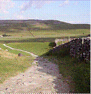
The characteristic scenery of the “Dales” is green upland pastures separated by dry-stone walls and grazed by sheep and cattle. The dales themselves are ‘U’ and ‘V’ shaped valleys, which were enlarged and shaped by glaciers, mainly in the most recent, Devensian ice age. The underlying rock is principally Carboniferous limestone (which results in a number of areas of limestone pavement) in places interspersed with shale and sandstone and topped with millstone grit. However, to the north of the Dent fault, the hills are principally older Silurian and Ordovician rocks, which make up the Howgill Fells.
Many of the upland areas consist of heather moorland, used for grouse shooting in the months following 12 August each year (the ‘Glorious Twelfth’).
Cave systems
Gaping Gill
Because of the limestone that runs throughout the “Dales” there are extensive cave systems present across the area making it one of the major areas for caving in the UK. Many of these are open to the public for tours and for caving.
9. Lake District
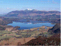
The Lake District, also known as The Lakes or Lakeland, is a rural area in North West England. A popular holiday destination, it is famous for its lakes and its mountains (or fells), and its associations with the early 19th century poetry and writings of William Wordsworth and the Lake Poets.
The central and most-visited part of the area is contained in the Lake District National Park, one of fourteen National Parks in the United Kingdom. It lies entirely within Cumbria, and is one of England's few mountainous regions. All the land in England higher than three thousand feet above sea level lies within the National Park, including Scafell Pike, the highest mountain in England
General geography
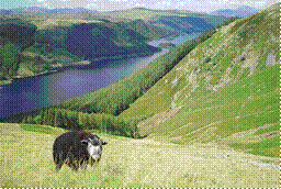
The Lake District is approximately 34 miles (55 km) across. Its features are a result of periods of glaciation, the most recent of which ended some 15,000 years ago. These include the ice-carved wide U-shaped valleys, many of which are now filled with the lakes that give the park its name. The upper regions contain a number of glacial cirques, which are typically filled with tarns. The higher fells are rocky, with lower fells being open moorland, notable for its wide bracken and heather coverage. Below the tree line, native oak woodlands sit alongside nineteenth century pine plantations. Much of the land is often boggy, due to the high rainfall. The Lake District is one of the most highly populated national parks. Its total area is near 885 square miles (2,292 km2), and the Lake District was designated as a National Park in 1951.
Другие рефераты на тему «Иностранные языки и языкознание»:
Поиск рефератов
Последние рефераты раздела
- Важнейшие требования к композиции документа
- Гармония речи и основные законы современной риторики
- Выразительность речи и ее условия
- Времена группы Simple
- Версия унификации и усовершенствования азерлийских национальных фамилий в Азербайджане
- Грамматика английского языка в примерах и упражнениях
- Грамматические правила русского языка