The National Parks of Great Britan
Geography
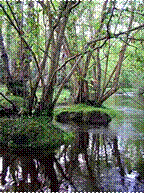
The New Forest Heritage Area covers about 580 km² (143321 acres), and the New Forest SSSI covers almost 300 km² (74131 acres), making it the largest contiguous area of un-sown vegetation in lowland Britain. It includes roughly:
146 km² (36077 acres) of broadleaf woodland
1
18 km² (29158 acres) of heathland and grassland
33 km² (8154 acres) of wet heathland
84 km² (20756 acres) of tree plantations (“inclosures”) established since the 18th century, including 80 km² (19768 acres) planted by the Forestry Commission since the 1920s.
It is drained to the south by two rivers, the Lymington and Beaulieu.
7. Exmoor
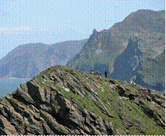
Exmoor is a National Park situated on the Bristol Channel coast of south west England. The park straddles two counties, with 71% of the park located in Somerset and 29% located in Devon. The total area of the park, which includes the Brendon Hills and the Vale of Porlock, covers 267 square miles (691.5 km2) of hilly open moorland and includes 34 miles (55 km) of coast. It is primarily an upland area with a dispersed population living mainly in small villages and hamlets. The largest settlements are Porlock, Dulverton, Lynton, and Lynmouth, which together contain almost 40% of the National Park population. Lynton and Lynmouth are combined into one parish and are connected by the Lynton and Lynmouth Cliff Railway.
Prior to being a park, Exmoor was a Royal Forest and hunting ground, which was sold off in 1818. Exmoor was one of the first British National Parks, designated in 1954, under the 1949 National Parks and Access to the Countryside Act, [1] and is named after the main river that flows out of the district, the River Exe.
Several areas of the moor have been declared a Site of Special Scientific interest due to the flora and fauna. This title earns the site some legal protection from development, damage, and neglect. In 1993 Exmoor was also designated as an Environmentally Sensitive Area.
History
There is evidence of occupation of the area by people from times, onward. In the Neolithic period, people started to manage animals and grow crops on farms cleared from the woodland, rather than act purely as hunters and as gatherers It is also likely that extraction and smelting of mineral ores to make metal tools, weapons, containers and ornaments started in the late Neolithic, and continued into the bronze and iron ages. An earthen ring at Parracombe is believed to be a Neolithic henge dating from 5000-4000 BC, and “Cow Castle", which is where White Water meets the River Barle, is an Iron Age fort at the top of a conical hill. [25] Tarr Steps are a prehistoric (circa 1000 BC) clapper bridge across the River Barle, about 2.5 miles (4 km) south east of Withypool and 4 miles (6 km) north west of Dulverton. The stone slabs weigh up to 5 long tons (5,080 kg) apiece and the bridge has been designated by English Heritage as a grade I listed building, to recognise its special architectural, historical or cultural significance. There is little evidence of Roman occupation apart from two fortlets on the coast
Holwell Castle, at Parracombe, was a Norman motte and bailey castle built to guard the junction of the east-west and north-south trade routes, enabling movement of people and goods and the growth of the population Alternative explanations for its construction suggest it may have been constructed to obtain taxes at the River Heddon bridging place, or to protect and supervise silver mining in the area around Combe Martin. It was 131 feet (40 m) in diameter and 20 feet (6 m) high above the bottom of a rock cut ditch which is 9 feet (3 m) deep. It was built, in the late 11th or early 12th century, of earth with timber palisades for defence and a one or two storey wooden dwelling. It was probably built by either Martin de Tours, the first lord of Parracombe, William de Falaise (who married Martin’s widow) or Robert FitzMartin, although there are no written records to validate this. The earthworks of the castle are still clearly visible from a nearby footpath, but there is no public access to them. During the Middle Ages, sheep farming for the wool trade came to dominate the economy. The wool was spun into thread on isolated farms and collected by merchants to be woven, fulled, dyed and finished in thriving towns such as Dunster. The land started to be enclosed and from the 17th century onwards larger estates developed, leading to establishment of areas of large regular shaped fields. During the 16th and 17th centuries the commons were overstocked with agisted livestock, from farmers outside the immediate area who were charged for the privilege. This led to disputes about the number of animals allowed and the enclosure of land. During this period a Royal Forest and hunting ground was established, administered by a warden, so that king Charles I could benefit from the fines and rents.
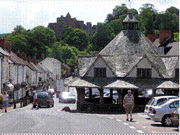
In the mid-17th century John Boevey was the warden. He built a house at Simonsbath, and for 150 years it was the only house in the forest. The Royal Forest was sold off in 1818. The Simonsbath House was bought along with the accompanying farm by John Knight for the sum of £50,000. Knight set about converting the Royal Forest into agricultural land. He and his family built most of the large farms in the central section of the moor, and built 22 miles (35 km) of metalled access roads to Simonsbath. He built a 29-mile (47 km) wall around his estate, much of which still survives.
In the mid-19th century a mine was developed alongside the River Barle. The mine was originally called Wheal Maria, then changed to Wheal Eliza. It was a copper mine from 1845-54 and then an iron mine until 1857, although the first mining activity on the site may be from 1552 At Simonsbath, a restored Victorian water-powered sawmill, which was damaged in the floods of 1992, has now been purchased by the National Park and returned to working order; it is now used to make the footpath signs, gates, stiles, and bridges for various sites in the park
Geology
Exmoor is an upland of sedimentary rocks classified as gritstones, sandstones, slate, shale and limestone, siltstones, and mudstones depending on the particle size. They are largely from the Devonian and early Carboniferous periods (the name Devonian comes from Devon, as rocks of that age were first studied and described here). As this area of Britain was not subject to glaciation, the plateau remains as a remarkably old landform. Quartz and iron mineralisation can be detected in outcrops and subsoil. The Glenthorne area demonstrates the Trentishoe Formation of the Hangman Sandstone Group. The Hangman Sandstone represents the Middle Devonian sequence of North Devon and Somerset. These unusual freshwater deposits in the Hangman Grits, were mainly formed in desert conditions. The underlying rocks are covered by moors and supported by wet, acid soil. The highest point on Exmoor is Dunkery Beacon; at 1,704 feet (519 m) it is also the highest point in Somerset.
Другие рефераты на тему «Иностранные языки и языкознание»:
Поиск рефератов
Последние рефераты раздела
- Важнейшие требования к композиции документа
- Гармония речи и основные законы современной риторики
- Выразительность речи и ее условия
- Времена группы Simple
- Версия унификации и усовершенствования азерлийских национальных фамилий в Азербайджане
- Грамматика английского языка в примерах и упражнениях
- Грамматические правила русского языка