The National Parks of Great Britan
4. The Broads National Park
The Broads is a network of mostly navigable rivers and lakes (known locally as broads) in the English counties of Norfolk and Suffolk. The Broads, and some surrounding land was constituted as a special area with a level of protection similar to a UK National Park by The
Norfolk and Suffolk Broads Act of 1988. The Broads Authority, a Special Statutory Authority responsible for managing the area, became operational in 1989
The total area is 303 km² (188 sq.miles), most of which is in Norfolk, with over 200 km (125 miles) of navigable waterways. There are seven rivers and sixty three broads, mostly less than twelve feet deep. Thirteen broads are generally open to navigation, with a further three having navigable channels. Some broads have navigation restrictions imposed on them in autumn and winter.
Although the terms Norfolk Broads and Suffolk Broads are used to identify those areas within the two counties respectively, the whole area is sometimes referred to as the “Norfolk Broads”. The Broads has the same status as the national parks in England and Wales but as well as the Broads Authority having powers and duties almost identical to the national parks it is also the third largest inland navigation authority. Because of its navigation role the Broads Authority was established under its own legislation on 1 April 1989. More recently the Authority wanted to change the name of the area to The Broads National Park in recognition of the fact that the status of the area is equivalent to the rest of the national park family but was unable to get agreement from all the different parties. The Private Bill the Authority is promoting through Parliament is largely about improving public safety on the water and the Authority did not want to delay or jeopardise these provisions for the name issue, so the provision was dropped before the Bill was deposited in Parliament.
History
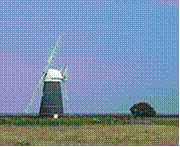
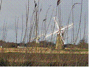
For many years the broads were regarded as natural features of the landscape. It was only in the 1960s that Dr Joyce Lambert proved that they were artificial features, the effect of flooding on early peat excavations. The Romans first exploited the rich peat beds of the area for fuel, and in the Middle Ages the local monasteries began to excavate the peat lands as a turbary business, selling fuel to Norwich and Great Yarmouth. The Cathedral took 320,000 tonnes of peat a year. Then the sea levels began to rise, and the pits began to flood. Despite the construction of windpumps and dykes, the flooding continued and resulted in the typical Broads landscape of today, with its reed beds, grazing marshes and wet woodland.
The Broads have been a favourite boating holiday destination since the early 20th century. The waterways are lock-free, although there are three bridges under which only small cruisers can pass. The area attracts all kinds of visitors, including ramblers, artists, anglers, and bird-watchers as well as people “messing about in boats". There are a number of companies hiring boats for leisure use, including both yachts and motor launches. The Norfolk Wherry, the traditional cargo craft of the area, can still be seen on the Broads as some specimens have been preserved and restored.
Ted Ellis, a local naturalist, referred to the Broads as “the breathing space for the cure of souls”.
A great variety of boats can be found on the Broads, from Edwardian trading wherries to state-of-the-art electric or solar-powered boats.
Geography
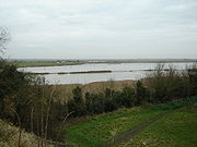
The point at which the River Yare and the River Waveney merge into Breydon Water
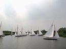
Yachts on the Norfolk Broads
![]()
How Hill
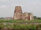
St. Benet’s Abbey
The Broads largely follows the line of the rivers and natural navigations of the area. There are seven navigable rivers, the River Yare and its (direct and indirect) tributaries the Rivers Bure, Thurne, Ant, Waveney, Chet and Wensum. There are no locks on any of the rivers (except for Mutford lock in Oulton Broad that links to the saltwater Lake Lothing in Lowestoft), all the waterways are subject to tidal influence. The tidal range decreases with distance from the sea, with highly tidal areas such as Breydon Water contrasted with effectively non-tidal reaches such as the River Ant upstream of Barton Broad.
The broads themselves range in size from small pools to the large expanses of Hickling Broad, Barton Broad and Breydon Water. The broads are unevenly distributed, with far more broads in the northern half of Broadland (the Rivers Bure, Thurne and Ant) than in the central and southern portions (the Rivers Yare, Waveney, Chet and Wensum). Individual broads may lie directly on the river, or are more often situated to one side and connected to the river by an artificial channel or dyke.
Besides the natural watercourses of the rivers, and the ancient but artificial broads, there is one more recent navigation canal, the lock-less New Cut which connects the Rivers Yare and Waveney whilst permitting boats to by-pass Breydon Water.
There is also a second navigable link to the sea, via the River Waveney and its link to Oulton Broad. Oulton Broad is part of the Broads tidal system, but is immediately adjacent to Lake Lothing which is itself directly connected to the sea via the harbour at Lowestoft. Oulton Broad and Lake Lothing are connected by Mutford Lock, the only lock on the broads and necessary because of the different tidal ranges and cycles in the two lakes.
In the lists below, names of broads are emboldened to help distinguish them from towns and villages.
5. Queen Elizabeth Park, British Columbia
Queen Elizabeth Park is a municipal park located in Vancouver, British Columbia, on Little Mountain (elevation approximately 168 metres (550 feet) above sea level). Its surface was scarred at the turn of the twentieth century when it was quarried for its rock, which served to build Vancouver’s first roadways.
History
In 1930, the park’s floral future was somewhat revealed when the BC Tulip Association suggested the notion of transforming the quarries into sunken gardens. By the end of that decade, the site had been turned over to the Vancouver Park Board for park and recreation purposes, and was dedicated as such by King George VI and his consort, Queen Elizabeth (the present Queen’s late mother) on their much lauded visit to Vancouver in 1939, as King and Queen of Canada. From that time, Park staff incrementally transformed the overgrown hillsides into Canada’s first civic arboretum, with a generous donation from the Canadian Pulp and Paper Association. The popular quarry gardens were designed by Park Board Deputy Superintendent Bill Livingstone and were unveiled in the early 1960s.
Другие рефераты на тему «Иностранные языки и языкознание»:
Поиск рефератов
Последние рефераты раздела
- Важнейшие требования к композиции документа
- Гармония речи и основные законы современной риторики
- Выразительность речи и ее условия
- Времена группы Simple
- Версия унификации и усовершенствования азерлийских национальных фамилий в Азербайджане
- Грамматика английского языка в примерах и упражнениях
- Грамматические правила русского языка